In an increasingly data-driven world, the demand for location intelligence has never been greater. From urban planning to environmental monitoring, the ability to capture, analyze, and interpret geospatial data is revolutionizing how industries make informed decisions. For organizations seeking to harness the power of spatial analytics, professional geospatial data services offer the precision, accuracy, and scalability needed to manage complex geographical information efficiently.
Geospatial data services encompass a wide range of capabilities, from aerial data collection and mapping to geospatial analytics and visualization. Companies like Aeroskape are at the forefront of this transformation, combining advanced drone technology and data processing to deliver actionable insights that drive smarter project outcomes.
What Are Geospatial Data Services?
Geospatial data services refer to the collection, analysis, and presentation of data that is tied to specific geographic locations. Using technologies such as GPS, remote sensing, LiDAR, and photogrammetry, specialists capture and process detailed spatial information. This data can then be visualized through maps, 3D models, or interactive dashboards, helping businesses and governments better understand the physical world around them.
Whether it’s tracking infrastructure development, assessing land use, or managing natural resources, geospatial data plays a critical role in modern decision-making. The precision and scale of data derived from these services allow stakeholders to optimize resources, minimize risks, and plan strategically for future growth.
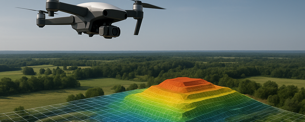
The Power of Aerial and Drone-Based Geospatial Data Collection
While satellite and ground-based surveys have been long-standing methods for geospatial data gathering, drone-based systems have rapidly become the preferred option for their flexibility and cost-effectiveness. Drones can capture high-resolution imagery and elevation data over large or hard-to-reach areas, offering unparalleled accuracy at a fraction of the time required by traditional methods.
Through aerial imaging and advanced sensors, companies can create detailed topographic maps, digital terrain models, and volumetric analyses that provide valuable insights into both natural and built environments. The adaptability of UAVs makes them ideal for applications ranging from construction site mapping to environmental restoration.
Why Accuracy Matters in Geospatial Data
Precision is the foundation of effective geospatial analysis. Inaccurate or incomplete data can lead to flawed interpretations and costly mistakes. Professional geospatial data services utilize cutting-edge hardware and software to ensure high accuracy and reliability. Calibrated sensors, ground control points, and rigorous data validation processes ensure that every dataset meets industry standards and project requirements.
Applications Across Diverse Industries
Construction and Infrastructure Development
Geospatial data supports every phase of construction projects, from site selection to final inspection. By integrating aerial mapping with digital modeling tools, project teams can visualize terrain conditions, monitor progress, and detect potential issues before they escalate. For large-scale infrastructure developments such as highways, bridges, or energy plants, geospatial intelligence ensures precise alignment, material management, and compliance with regulatory standards.
Environmental Monitoring and Land Management
Environmental agencies and organizations rely on geospatial data to track land use changes, monitor vegetation health, and evaluate environmental impacts. High-resolution imagery and temporal data comparisons allow for accurate assessments of deforestation, erosion, and habitat loss. This information guides conservation strategies and sustainable land management practices, helping protect natural ecosystems while supporting responsible development.
Urban Planning and Smart Cities
As cities grow, geospatial data becomes essential for planning efficient, livable spaces. Planners use spatial data to assess population density, transportation networks, and infrastructure capacity. With accurate geospatial insights, municipalities can optimize public services, reduce congestion, and enhance resilience against natural disasters. The integration of geospatial data into smart city initiatives enables real-time monitoring and adaptive resource management.
Agriculture and Resource Management
Precision agriculture relies heavily on geospatial data to optimize crop yields and reduce waste. Drones equipped with multispectral sensors provide farmers with data on soil conditions, irrigation efficiency, and crop health. This real-time intelligence allows for targeted interventions that improve productivity while conserving resources. Beyond agriculture, geospatial data also aids in managing water resources, mining operations, and forestry planning.
Key Advantages of Professional Geospatial Data Services
Partnering with a professional geospatial data provider delivers measurable benefits that extend beyond the data itself. The expertise and technology involved ensure that organizations can make strategic, evidence-based decisions quickly and confidently.
Enhanced Decision-Making
Geospatial insights empower decision-makers with a deeper understanding of location-specific challenges and opportunities. By visualizing spatial relationships and patterns, stakeholders can make informed choices that align with both operational objectives and environmental constraints.
Time and Cost Efficiency
Automated aerial surveys and streamlined data processing drastically reduce the time and resources required for traditional field surveys. This efficiency translates into faster project turnarounds and reduced costs without compromising accuracy.
Scalability and Integration
Geospatial data can be easily scaled to accommodate projects of any size—from small site surveys to national mapping initiatives. Additionally, the data can be integrated with existing software systems like GIS platforms, BIM tools, and analytics dashboards, ensuring seamless workflows and better collaboration among teams.
Why Partner with Aeroskape for Geospatial Data Solutions?
When it comes to reliable and high-quality geospatial data services, partnering with experienced professionals is key. Check out Aeroskape, a leading provider of drone-based mapping and spatial analytics. Aeroskape combines advanced UAV technology with expert data processing to deliver accurate, actionable insights tailored to each project’s unique requirements.
With extensive experience across multiple industries, Aeroskape ensures that clients receive not only raw data but meaningful analysis that drives decision-making. Their commitment to innovation and precision makes them a trusted partner for businesses seeking to harness the full power of spatial intelligence.
The Future of Geospatial Data and Emerging Technologies
As technology continues to evolve, the future of geospatial data services looks increasingly promising. Artificial intelligence (AI) and machine learning are enhancing data processing, allowing for faster and more accurate pattern recognition. Predictive analytics powered by AI can identify potential risks or opportunities before they occur, enabling proactive management.
Additionally, the integration of real-time IoT sensors with geospatial platforms allows for continuous monitoring of physical assets and environmental conditions. Combined with cloud-based GIS systems, these innovations are transforming static maps into dynamic, interactive tools for decision-making.
As regulatory frameworks expand and data interoperability improves, industries will find even greater value in the accessibility and precision of geospatial data services. The synergy between UAV technology, AI analytics, and big data visualization will redefine how we perceive and interact with the world around us.
Shaping a Smarter, Data-Driven Future
Geospatial data services are no longer optional—they’re essential to the future of planning, construction, and environmental management. They provide the framework for smarter, more efficient, and sustainable decision-making across every sector. By leveraging these technologies, organizations can unlock new levels of clarity and control in their operations.
